
Hiking America - California
California · Western Terminus
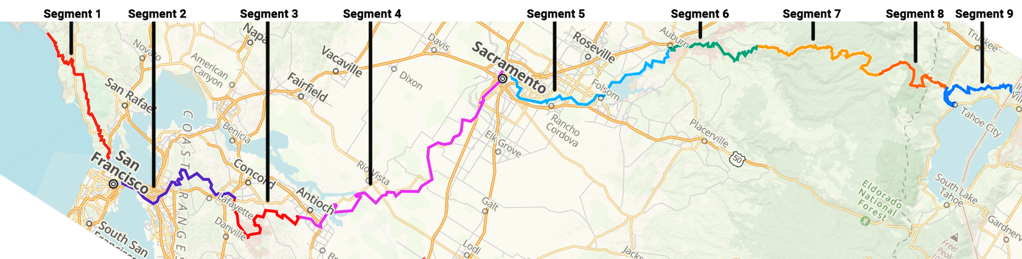
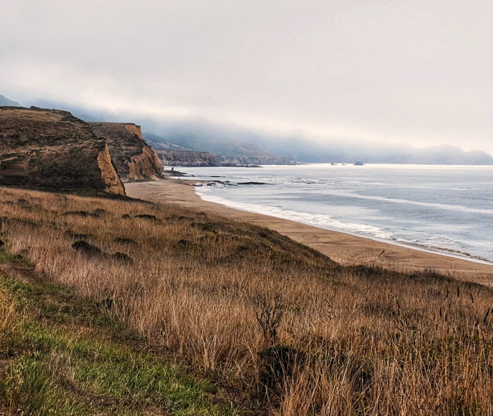
California is the bookend of the American Discovery Trail. The western terminus sits at Limantour Beach in Point Reyes — for a westbound hiker it's the final stretch of a coast-to-coast walk; for an eastbound hiker it's mile zero. Either way, it's the most varied state on the route.
In a single crossing you go from Pacific surf to the Golden Gate, across the regional parks of the Bay Area, over the flat heat of the Central Valley, then up into the Sierra Nevada high country around Lake Tahoe. Few states ask you to be a coastal walker, an urban navigator, and a mountain hiker in the same stretch.
Segment Guides
Four Californias in One Crossing
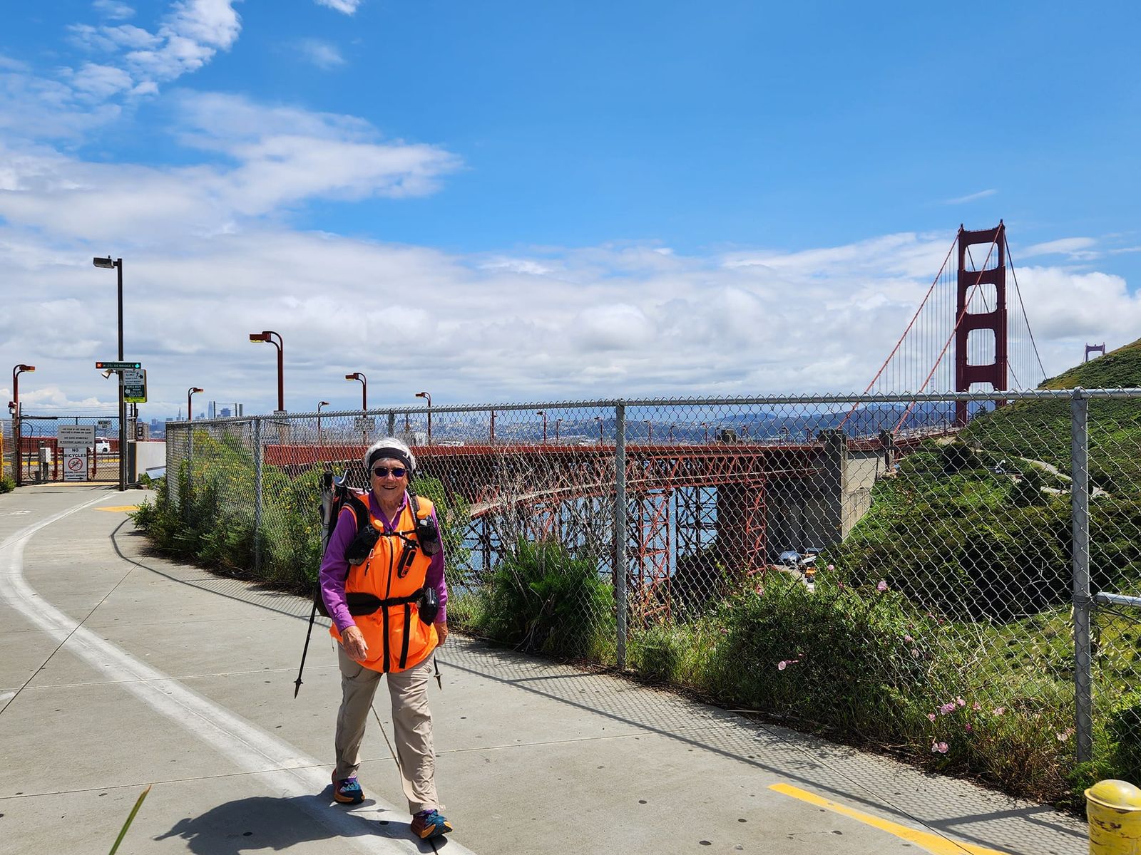
The Coast and the Golden Gate
You start (or finish) on the sand at Limantour Beach, work through Point Reyes and Marin, and walk across the Golden Gate Bridge. This is cool, foggy, marine-layer country, and the walking is easy on established paths. The planning here is about lodging and transit in a dense, expensive area — not wilderness.
The Bay Area Crossing
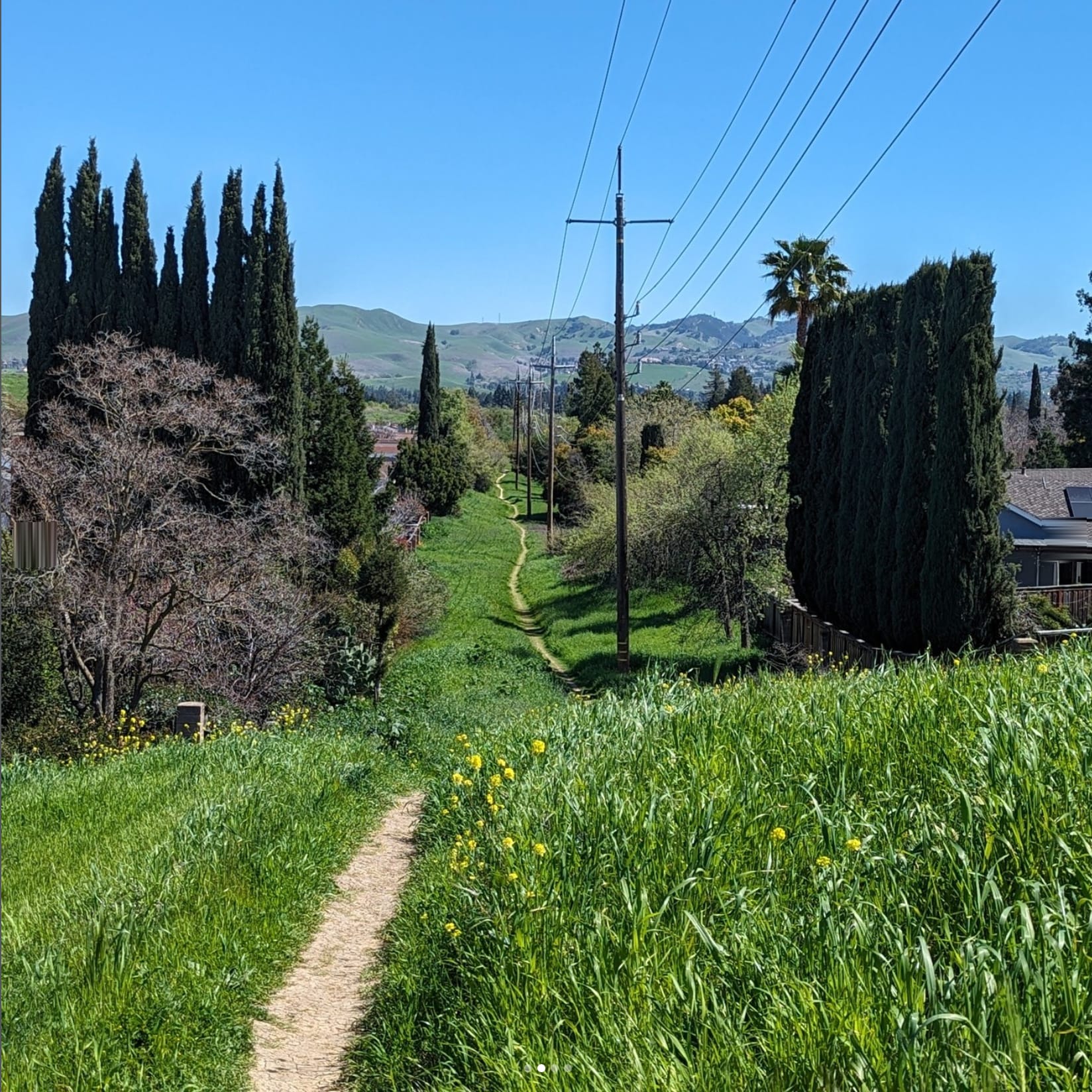
From the Golden Gate the route runs through the East Bay to Walnut Creek and Antioch. Expect a mix of urban trail, road walking, and regional parks, with Mount Diablo standing over the Walnut Creek section. This is urban thru-hiking: water and food are everywhere, but legal camping is scarce, so you're solving where to sleep and how to move through town, not where to find your next water source.
The Central Valley to Sacramento
From Antioch the trail flattens out and crosses the Delta and river bottoms toward Sacramento. It's flat, hot, and exposed, with stretches of road. Heat management matters more than terrain here, and Sacramento is a genuine resupply and reset point before the ground starts to climb.
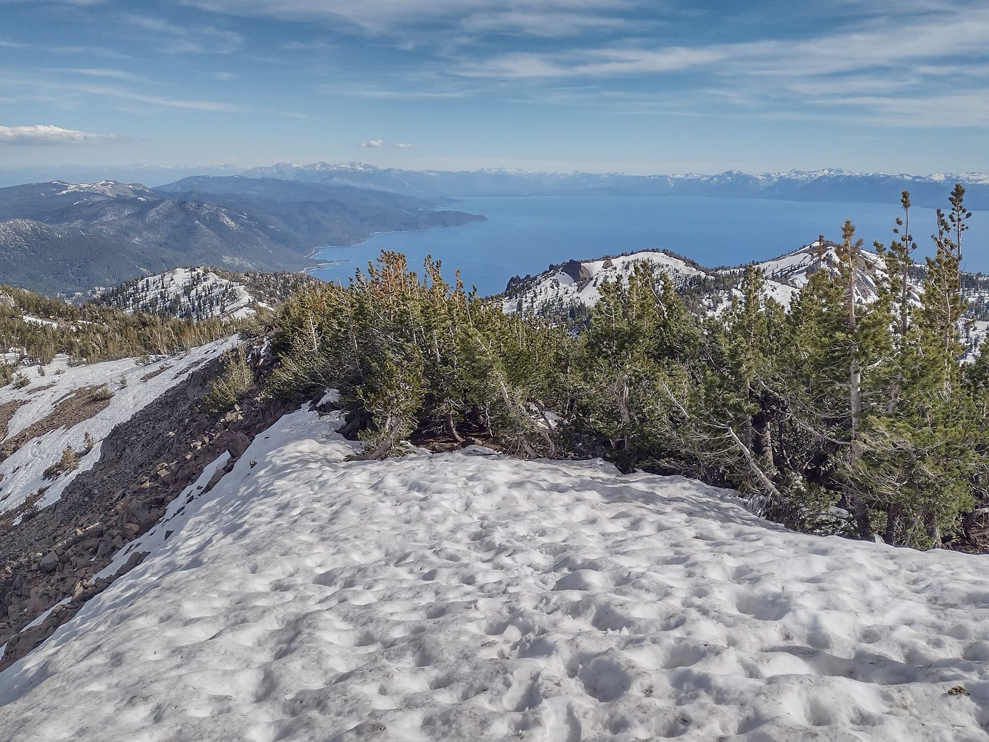
The Sierra Nevada
From Sacramento the route climbs through Auburn and Foresthill into the Sierra, following the historic Western States Trail to French Meadows Reservoir and on toward Palisades Tahoe, then joins the Tahoe Rim Trail around the lake to the Nevada line. This is the crux of California. Because the ADT rides established, signed trails through here, route-finding is more straightforward than the cross-country basin-and-range of Nevada next door — but elevation and snow run the show.
Timing and the Sierra Snowpack
Your California timing is governed by the Sierra high country, not the lowlands. We track the snowpack at three stations along this stretch — Tahoe City (6,797 ft), Palisades Tahoe (8,013 ft), and Mount Rose (8,801 ft) — and log the date each one drops below three inches in spring and climbs back above it in fall. That's the practical open-and-close window for the high sections of the route.
Over the last fifteen years, the lower Tahoe City station has cleared around April 23, Palisades around May 27, and Mount Rose — the highest, and the last to open — around June 7. In fall the order reverses: Mount Rose closes first, near October 30, with Palisades following around November 2. The dependable window for the high country runs roughly early June through late October.
Mount Rose has opened as early as May 11 and as late as July 10 — a seven-week spread depending on the year, so watch the snowpack, not the calendar. Check the spring-open and fall-close table below, updated every season, against current conditions before you lock in dates.
Westbound finishers race the first snows to close out the high sections and drop to the coast. Eastbound hikers starting at Limantour usually wait for melt-out before the Tahoe-area trail opens. Because Limantour Beach is the terminus, California is also where the dual-directional flip pays off: a hiker can start or flip to the coast and walk back east to catch the Sierra and Nevada in a better window.
Water, Resupply, and Logistics
California flips the usual long-trail script. On most of the route water is rarely the problem — logistics are. The constraint changes with the landscape.
On the coast and through the Bay Area, water and food are easy and legal camping is hard, so plan lodging and transit. In the Central Valley, heat and exposure are the issue; carry more water than the mileage suggests and time the hot stretches. In the Sierra, water in the high country is reliable and the real constraints become elevation, weather, and food-storage rules in the Tahoe area.
One firm rule in the Tahoe high country: a hard-sided bear canister is required for every overnight along the entire Tahoe Rim Trail. Any night your camp falls on the TRT portion of the route, you carry one. The Western States Trail sections have no canister requirement.
For resupply, Sacramento and the Auburn–Foresthill corridor are solid stops. Coastal Marin and the Tahoe-area towns work but cost more than your average trail town.
Every water source, camp, road crossing, and resupply point along the California route is mapped in our Gaia GPS data. When you join Hiking America, we email you an invitation to the California Gaia GPS folder, and the downloadable PDF segment guides live in the members area at the foot of this page.
What a Smart California Crossing Looks Like
Treat California as several different hikes stitched together, and match your plan to each section's real constraint rather than to one idea of "California." Watch the Sierra snowpack instead of the calendar. Solve lodging and transit before the Bay Area, manage heat in the Valley, and manage elevation and weather in the Sierra. And keep your route current — established trails still close for fire, slides, and snow, so we update the guides and Gaia data each season. 🥾⛰️
When the Sierra Opens and Closes
We track snowpack at three stations along this stretch of the Sierra and record when each one clears in spring and when it locks back up in fall. Mount Rose, the highest, is the last to open and among the first to close. The year-to-year spread is wide, so read these alongside current conditions before you set your dates.
Date each station's snowpack drops below 3 inches.
| Year | Palisades8,013 ft | Tahoe City6,797 ft | Mount Rose8,801 ft | Days P→R |
|---|---|---|---|---|
| 2026 | 5/10 | 4/15 | 5/23 | 13 |
| 2025 | 5/26 | 4/11 | 6/3 | 8 |
| 2024 | 5/23 | 5/6 | 6/5 | 13 |
| 2023 | 6/16 | 5/20 | 7/9 | 23 |
| 2022 | 5/18 | 5/11 | 5/28 | 10 |
| 2021 | 5/6 | 3/31 | 5/11 | 5 |
| 2020 | 5/21 | 4/12 | 5/27 | 6 |
| 2019 | 6/18 | 5/6 | 7/4 | 16 |
| 2018 | 5/21 | 4/10 | 6/6 | 16 |
| 2017 | 6/20 | 5/5 | 7/10 | 20 |
| 2016 | 5/28 | 4/24 | 6/9 | 12 |
| 2015 | 5/4 | 4/8 | 5/25 | 21 |
| 2014 | 5/15 | 4/26 | 5/23 | 8 |
| 2013 | 5/11 | 3/18 | 5/20 | 9 |
| 2012 | 5/21 | 4/21 | 5/20 | -1 |
| 2011 | 7/7 | 5/31 | 7/10 | 3 |
| 2010 | 6/20 | 5/13 | 6/24 | 4 |
| 2009 | 5/29 | 4/18 | 6/6 | 8 |
| 15-yr avg | 5/23 | 4/20 | 6/4 | 12 |
| Last 10 yr | 5/27 | 4/24 | 6/9 | 13 |
| Last 5 yr | 5/24 | 4/30 | 6/7 | 13 |
| Earliest | 5/4 | 3/18 | 5/11 | 7 |
| Latest | 7/7 | 5/31 | 7/10 | 3 |
Date each station first holds more than 3 inches.
| Year | Palisades8,013 ft | Tahoe City6,797 ft | Mount Rose8,801 ft | Days R→P |
|---|---|---|---|---|
| 2025 | 10/14 | 12/23 | 10/13 | 1 |
| 2024 | 11/12 | 11/24 | 11/12 | 0 |
| 2023 | 11/7 | 12/7 | 11/7 | 0 |
| 2022 | 11/1 | 11/1 | 11/1 | 0 |
| 2021 | 10/17 | 12/9 | 10/22 | -5 |
| 2020 | 11/8 | 11/18 | 11/8 | 0 |
| 2019 | 11/26 | 11/26 | 11/19 | 7 |
| 2018 | 11/21 | 11/22 | 11/21 | 0 |
| 2017 | 11/4 | 12/3 | 11/4 | 0 |
| 2016 | 10/30 | 11/19 | 10/15 | 15 |
| 2015 | 11/3 | 11/24 | 11/2 | 1 |
| 2014 | 11/19 | 12/15 | 10/31 | 19 |
| 2013 | 10/28 | 12/3 | 10/28 | 0 |
| 2012 | 10/22 | 10/22 | 10/22 | 0 |
| 2011 | 10/4 | 11/3 | 10/5 | -1 |
| 2010 | 10/31 | 11/8 | 10/5 | 26 |
| 2009 | 11/12 | 11/20 | 11/18 | -6 |
| 15-yr avg | 11/2 | 11/24 | 10/30 | 2 |
| Last 10 yr | 11/4 | 11/27 | 11/2 | 2 |
| Last 5 yr | 10/28 | 11/30 | 10/29 | 0 |
| Earliest | 10/4 | 10/22 | 10/5 | -1 |
| Latest | 11/26 | 12/23 | 11/21 | 5 |
Source: Hiking America snowpack tracking, Tahoe-area stations. © Hiking America LLC — updated each spring and fall.