
Hiking America
Hiking America · Trail Maps & Guides
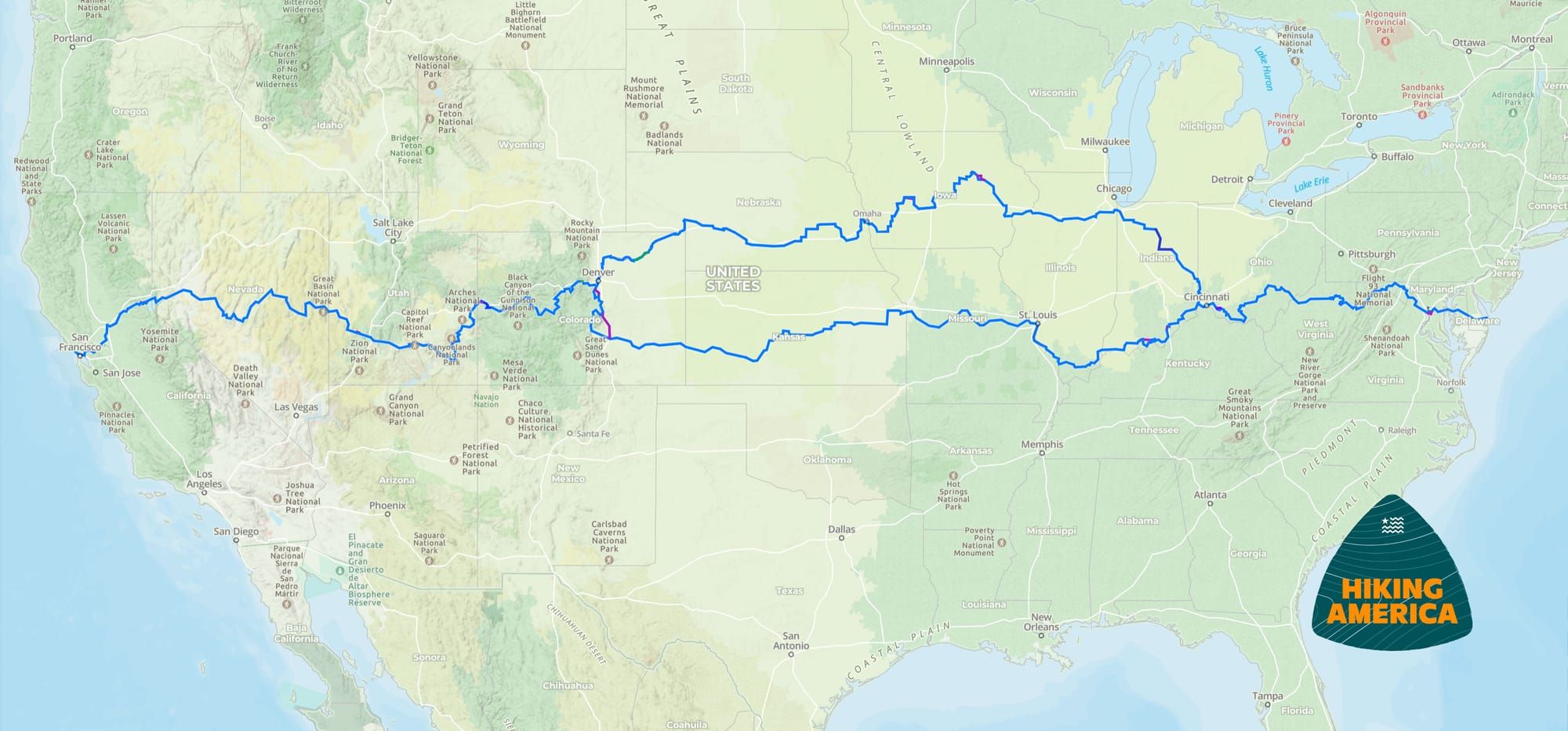
The American Discovery Trail runs coast to coast, from Point Reyes, California to Cape Henlopen, Delaware — continuous, dual-directional, and stitched together from Sierra passes, prairie county roads, canal towpaths, and coastal rail-trail. Between the wild stretches there's rarely a blaze, so the route lives or dies on the quality of its maps.
Hiking America maps all 15 states across both the northern and southern routes, in both directions: turn-by-turn guides, a curated Gaia GPS layer, and reroutes and water reports from hikers out on the trail this season. The 15 states are grouped by route below, west to east.
The Trail at a Glance
West of Denver, every ADT hiker walks the same trail. It splits near Sheridan, Colorado into a northern route through Nebraska and Iowa and a southern route through Kansas and Missouri, then the two rejoin near Cincinnati at Elizabethtown, Ohio and run east as one line to the Atlantic. A thru-hiker picks one side or the other — about 4,900 miles either way — not both.
What's in Every State Guide
Each state guide breaks the crossing into sections: the terrain you'll actually walk, when the season opens and closes, where water and resupply sit, and the turn-by-turn segment guides you download and carry. The waypoints are curated for what's reachable on foot from the corridor, not a phone-book dump of everything a town happens to have.
The curated Gaia GPS layer maps every water source, camp, road crossing, and resupply point along your route. California, Maryland, and Delaware are open as free previews, so you can read a full guide and see the format before you decide.
The rest of the ADT tracks are subscription-only. A membership emails you an invitation to each state's Gaia GPS folder and unlocks the downloadable PDF segment guides, for $7 a month or $70 a year. The guides and GPS data are corrected season to season against reports from hikers currently walking the trail, so what you carry reflects the route as it stands now — closures, reroutes, and new water sources included.
Every State, West to East
The trail splits near Denver. Pick the route you're hiking — the split states below (Colorado, Illinois, Indiana, Ohio) each have a separate guide for the northern and the southern line.
Shared West
Northern Route
Southern Route
Shared East
Trail Maps & Guides to the American Discovery Trail
Independent, Crowdsourced, Updated and Verified – Continuously.
Northern Route
* Includes a FREE Preview!