
Hiking America - Utah
Trail Maps & Guides to the American Discovery Trail
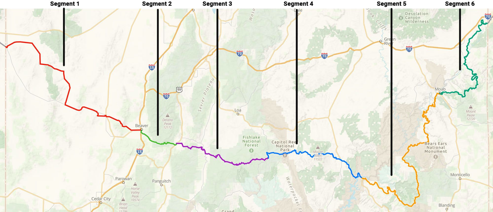
Segment 1 - Nevada State Line to Beaver
Length: 116.673 miles
Ascent: 7532 ft
Descent: 6925 ft
Key Points:
This segment of the American Discovery Trail is challenging. It's crucial to note that there are no water sources after you begin for the first 90 miles. This stretch goes through the Ferguson Desert, up to Crystal Peak, and then through the Wah-Wah Valley to Milford. From Milford, the trail leads to Soldier Pass in the Mineral Mountains and then through the Escalante Desert before finally reaching Beaver.
Towns & Points of Interest:
Garrison: This is likely the last water availability spot until Milford, which is 91 miles away. Garrison has a post office, water pump, and an elementary school. Historically, Garrison was founded as a cattle rustling and outlaw community in the 1850s.
Frisco (Ghost Town): Known as the wildest town in the Great Basin with 23 saloons. Drinking water had to be freighted in — a historical marker about the old mining town and a covered picnic table.
Hiker Tips & Notes:
Water Caches: Given the lack of water sources, previous hikers have set out water caches at specific locations. Planning and setting out water caches before attempting this segment is essential.
Dispersed Camping: There are areas where previous hikers have camped along the trail.
Wah Wah Ranch: Hikers have mentioned the hospitality of the ranch owners, Mark and Nikki, who offer water and a place to rest.
Safety & Updates: The guide is a living document with updates from hikers and bikers. It's essential to check for the latest version and be aware of any changes or new information.
Segment 2 - Beaver to Circleville
Length: 28.265 miles
Ascent: 4261 ft
Descent: 4071 ft
Terrain: Mixed
Towns and Points of Interest:
Beaver:
Named for the beavers found in the river and mountain streams.
Birthplace of Robert Leroy Parker, aka "Butch Cassidy". His boyhood home is in Circleville.
Services in Beaver:
Library: M-Th 11-6
Laundromat: Beaver Valley Cleaners, M-SA 8-9
Post Office: 20 S Main St, Beaver, UT 84713, M-F 9-4:30, Sa 9-12
Food: Crave (The Pizza Place), The Creamery (Ice Cream and Cheese store)
Resupply: Mike's Food Town, Freemont Market (Specialty Grocery store)
Water: Water Spigot in Main Street Park
Lodging: Best Western
Circleville:
Named for the shape of the valley, Circle Valley, which is circled by mountains except where the Sevier River flows.
Services in Circleville:
Lodging: Butch Cassidy's Hideout (with a restaurant), The Bunkhouse
Post Office: 143 W Main St, Circleville, UT 84723
Trail Highlights:
The trail passes through Beaver County and Piute County.
For a portion of the segment, hikers will travel on the Paiute ATV Trail, which is popular during March-May and September-October.
The trail offers various camping spots, water sources, and points of interest.
Segment 3 - Circleville to Boulder (Roundup Flat)
Length: 73.856 miles
Ascent: 13,973 ft
Descent: 10,459 ft
Terrain: Mixed
Key Points:
Circleville: This town is named for the shape of the valley it's located in, Circle Valley. The valley is circled by mountains except where the Sevier River flows through.
Morgan Ranches: A significant dairy cattle and milk operation.
Garfield County: The route enters this county after a few miles.
Dixie National Forest: The trail enters this forest and offers scenic views and a reliable water source at Rocky Ford Creek.
Antimony: A town known for its fireworks display each 4th of July. It boasts the Antimony Mercantile for supplies and has a post office. The town is also known for its homemade pies.
Dixie National Forest (again): The route re-enters this forest, following the Poison Creek for a significant portion. The creek flows better at the bottom and might be dry at the top. The scenery changes from boulders and aspens to alpine meadows. The route offers breathtaking views of the surrounding mountains and plateaus.
Notes:
The guide contains various waypoints, turns, and specific directions for the hiker.
There are several points of interest, towns, and services along the way, including grocery stores, campgrounds, and restaurants.
Hikers are advised to be cautious during winter months due to deep snow and potential flash floods during heavy rain events.
Segment 4 - Boulder (Roundup Flat) to Hite
Length: 88.563 miles
Ascent: 9724 ft
Descent: 15173 ft
Terrain: Mixed
Key Features:
Water Notes: The availability of water from creeks, streams, and springs can't be guaranteed and depends on recent snow melt/rainfall.
Towns and Areas of Interest:
Boulder (Roundup Flat): Starting point of the segment.
Oak Creek Campground: A notable stop with potable water.
Capitol Reef National Park: Requires a backcountry permit for camping.
McMillan Springs Campground: A BLM campground with amenities.
Hiker Tips:
Tips from previous hikers are included, such as advice on following cow paths along the water and rock hopping back and forth across Oak Creek.
Segment 5 - Hite to Moab
Length: 174.530 miles
Ascent: 16,417 ft
Descent: 16,519 ft
Key Features:
Hiker Notes: The guide includes crowdsourced notes from hikers, providing insights on missing signs, campsite spots, water sources, restaurants, and other useful information.
Towns & Points of Interest: The segment starts at Hite and ends at Moab. Along the way, hikers will pass through various landmarks, including:
Hite Marina Campground: Offers camping, water, and toilet facilities.
Fortknocker Canyon Road: A significant portion of the trail follows this road.
Bears Ears National Monument: A notable landmark along the route. Multiple stock ponds and springs where hikers can find water.
Manti-La Sal National Forest: Another major landmark on the route.
Recommendation for Hikers:
The Utah Segment 5 offers a mix of terrains and is dotted with landmarks, making it a scenic route for hikers. It's essential to be aware of the climbing sections and to plan water sources, especially in the drier areas. The guide's hiker notes can be particularly beneficial in this regard.
Segment 6 - Moab to Colorado State Line
Length: 110.413 miles
Ascent: 14,058 ft
Descent: 13,277 ft
Terrain: Mixed
Description:
Utah Segment 6 Eastbound follows the Kokopelli's Trail, a 142-mile multi-use trail in Eastern Utah and Western Colorado. The trail was named in honor of its mythic muse, Kokopelli. Starting in Moab, Utah, hikers will encounter two significant climbs, reaching elevations of 8,500 feet, up and over the La Sal Mountains. After descending to the Dewey Bridge and a brief paved section on Utah Route 128, the trail meanders north, roughly following the Colorado River into Colorado. The journey on Kokopelli's Trail continues in Colorado Segment 1 Eastbound.
Towns & Points of Interest:
Moab, Utah:
All Services available.
Fun Fact: You are 16 miles from the Colorado Line, but following the Kokopelli Trail, it will take 110 miles to reach it!
Sand Flats Recreation Area: Over 120 campsites in 9 campgrounds. Campsites are offered on a first-come, first-serve basis.
Trail Highlights:
Rotary Park: Water fountain and toilet available.
Sand Flats RA Entrance: Entering Sand Flats Recreation Area.
Sand Flats RA Campgrounds: A, B, and others with camping facilities.