
The Sierra Is Getting Hammered — Here's What It Means for Your ADT Timing
The Sierra just got 30+ inches in 24 hours. For eastbound ADT hikers counting on early May access, that early-crossing window just closed. Here's what the snow totals mean for your timeline. ⛰️

Two days ago, I posted an advisory about Colorado's record-low snowpack and what it might mean for ADT hikers planning a 2026 thru-hike. One of the points I made was that a low-snow year in Colorado could translate to earlier access through the Sierra Nevada — less snow to melt through, passes opening weeks ahead of schedule.
That assumption just got more complicated. 👀
The Sierra is currently getting pounded.
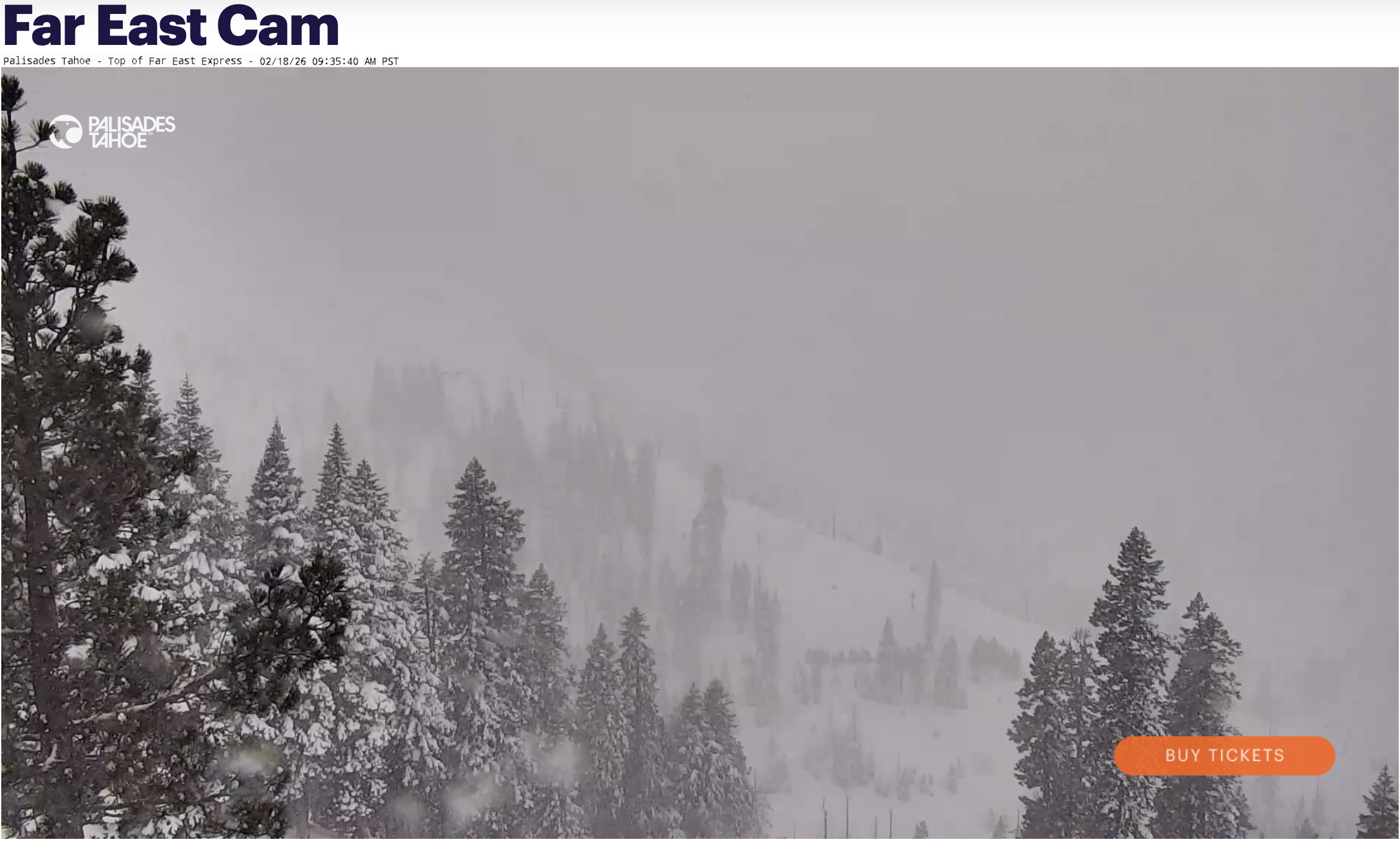
Above is the view from the top of the Far East Express ski lift at Palisades Tahoe this morning at 9:35 PST. The American Discovery Trail passes directly beneath this lift. According to OpenSnow's latest forecast, heavy snow that began falling across the Tahoe region and the Sierra Nevada earlier this week will continue, with two more significant storms rolling through today and Friday (February 18-20). Six feet so far, this week! We're talking about the kind of accumulation that materially changes the spring snowpack picture — exactly the kind of late-winter pattern that extends the melt season and pushes back typical crossing windows.
This is a perfect illustration of why trail intelligence needs to be current, not theoretical. Conditions change fast. Here's what I'm watching.
This Changes the Snowpack Math
The forecast through Friday shows heavy snow focused directly on the Sierra Nevada and Tahoe, with additional storms possible early next week. And when I say "heavy," here's what we're actually talking about:

As of this morning, 24-hour snow totals across the Tahoe region — where the ADT passes directly through Palisades Tahoe and north around Lake Tahoe into Nevada — include:
- Boreal Mountain: 30 inches
- Tahoe Donner: 27 inches
- Palisades Tahoe: 44 inches (where the ADT crosses)
OpenSnow's extended forecast suggests the Sierra could see an additional 3 to 7 feet of total accumulation over the next five to ten days.
That's not a dusting — that's meaningful accumulation landing right in the window when snowpack typically starts transitioning toward melt season.
What it means practically: the early-access advantage I mentioned in the Colorado post is probably off the table now. The passes that might have opened in mid-May under continued low-snow conditions are now more likely tracking back toward a typical late May window — maybe even later depending on what the next few weeks bring.
If you're eastbound and planning a late March or early April start date with the goal of hitting the Sierra by mid to late May, that crossing timeline deserves a second look right now. You may need to delay your start, plan for a longer wait on the western side of the passes, or build more flexibility into your early-trail pacing.
Late-Season Snow Extends the Melt Window
It's not just about total accumulation — it's about timing. When significant snow falls in mid-to-late February, you're adding fresh accumulation on top of the existing base right when the seasonal transition toward melt would normally be accelerating. Even though sun angles are stronger and melt rates are faster than early winter, late-season snow effectively resets the timeline for when high passes fully clear. The overall melt window extends, so safe crossing windows shift later into spring.
The practical effect: even if the total Sierra snowpack doesn't end up dramatically above normal by April 1st, the fact that a significant portion of it arrived late in the season means it takes longer to clear. High passes stay snowed in longer. Water levels stay high and fast longer. The safe crossing window shifts later into the calendar. But more snowpack means more reliable water through the summer months in areas where late-season sources can become scarce.
What to Watch Going Forward
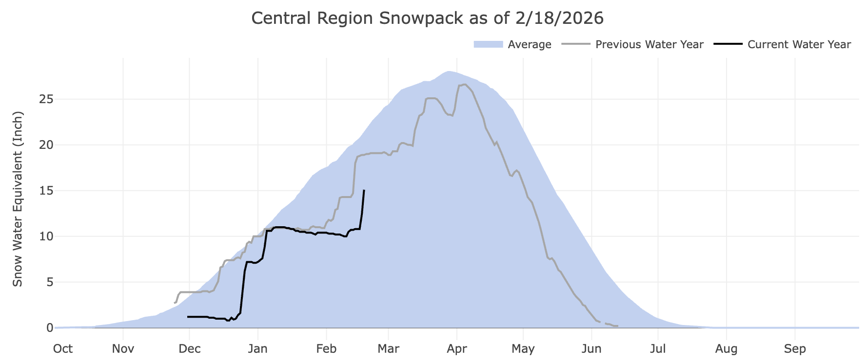
This week's storms are significant, but they're not the end of the story. This week's snow dramatically increased the Tahoe/Sierra snowpack (see chart above), but it is still below last year's and remains well below average.
The forecast for late February indicates continued active weather across the West, with warmer temperatures returning to the Rockies and the Sierra potentially seeing additional systems.
What matters now is how the rest of February and March play out. If this week's snow is an isolated event and the pattern shifts back toward warm and dry, the melt season could still arrive close to normal timing. If we see another round of late-winter storms in March, you're looking at a delayed Sierra crossing window — potentially well into June for safe passage.
Here's where to stay current:
OpenSnow's Sierra Forecast at opensnow.com (and inside Gaia GPS) tracks storm systems and snowfall in real time. They update frequently, and their daily forecasts provide a clear view of what's coming.
USDA NRCS California Snow Survey — same program as Colorado, different state. California's April 1st snow survey will be the definitive marker for how the Sierra season is shaping up. Bookmark https://snow.water.ca.gov/ and check it regularly starting in March.
We'll continue tracking Sierra conditions through HikingAmerica as well. If the picture shifts again — either toward earlier access or extended delays — I'll flag it.
The trail is still there. The conditions just keep evolving — which is exactly what they're supposed to do. 🥾
Hike Your Hike - John.


I'm Hiking America Credential Badge
Recognized by trail angels, hostels, and fellow hikers nationwide!
Get your Custom Hiking America Hiker Tag!
Only $19 for a Limited Time!
Always Free to Hiking America Members.