
ADT vs Great American Rail-Trail: Two Ways to Walk Across America
Both trails cross America. One is coast-to-coast, the other cross-country from D.C. to Washington State. But they're fundamentally different experiences. Here's how the American Discovery Trail and Great American Rail-Trail compare — and which one fits your goals.

One of the questions I'm getting more often lately — especially from hikers who've finished the ADT or are deep into planning mode — is this: what's the difference between the American Discovery Trail and the Great American Rail-Trail? And which one should I do?
It's a fair question. Both trails cross the country. Both are massive undertakings — the ADT at roughly 5,000 miles on a single route, the Great American at 3,700+. And Hiking America now provides GPS navigation for both of them. But they're fundamentally different experiences, and choosing the right one comes down to what kind of journey you're looking for.
Here's how I think about it — and what I'd want to know if I were deciding between the two.
The Basics
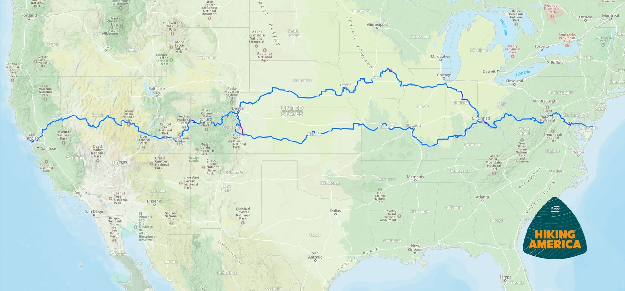
The American Discovery Trail stretches approximately 6,800 miles from Cape Henlopen, Delaware, to Point Reyes, California — the only non-motorized coast-to-coast trail in the United States. It crosses 15 states and Washington, D.C., and splits into northern and southern routes between Cincinnati and Denver. The northern route passes near Chicago; the southern through St. Louis. That 6,800-mile total combines both routes — most thru-hikers walk one or the other, covering roughly 4,800 to 5,000 miles.
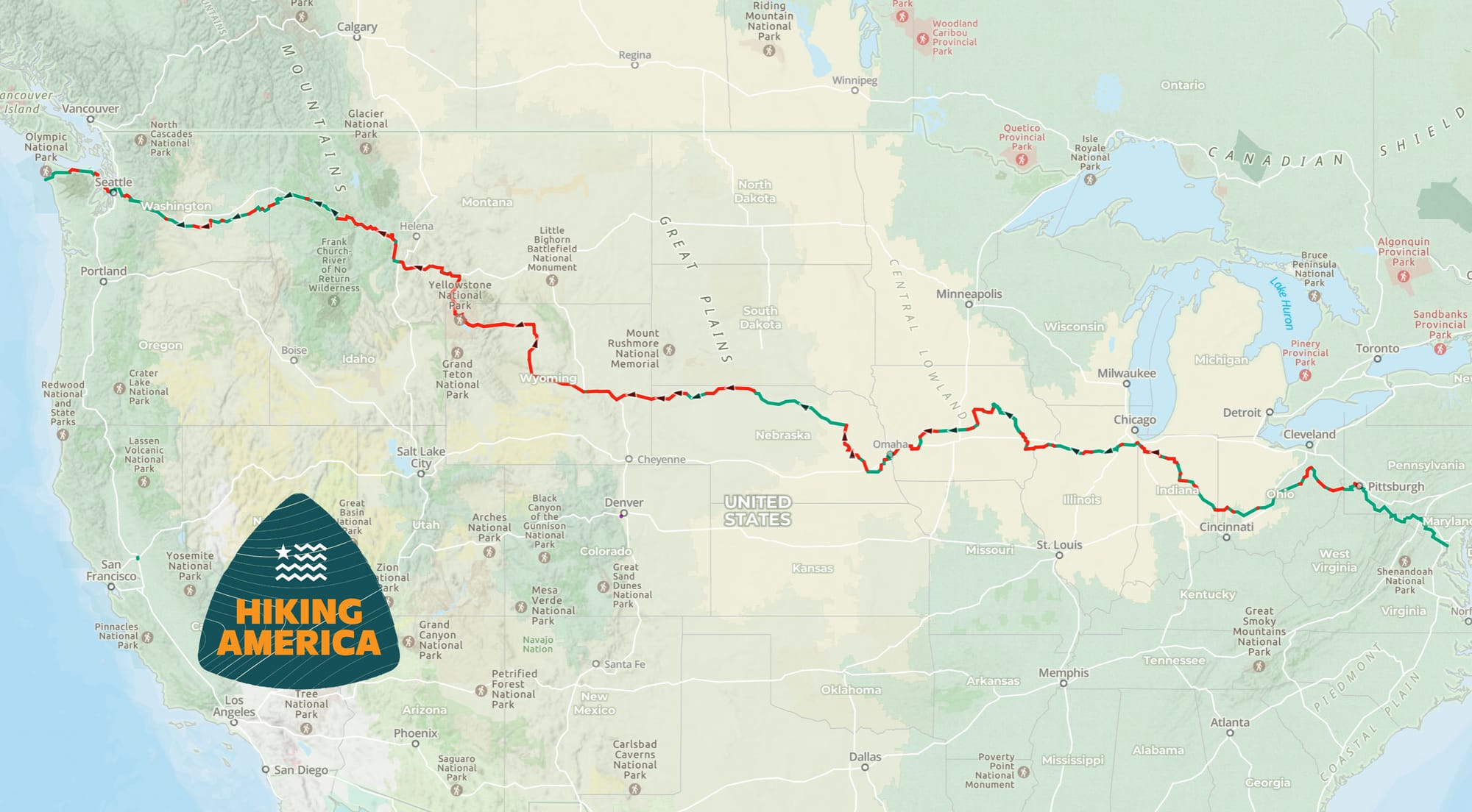
The Great American Rail-Trail runs more than 3,700 miles from Washington, D.C., to Washington State — a cross-country route, though not technically coast-to-coast since D.C. sits on the Potomac, not the Atlantic. It crosses 12 states and the District of Columbia, following a network of converted rail corridors, greenways, and multiuse paths — with the route currently about 56% complete. The remaining sections are gaps that haven't been built yet.
Both cross the country. Both are extraordinary commitments. But the similarities mostly end there.
Terrain and Trail Experience
This is where the two trails diverge most dramatically.
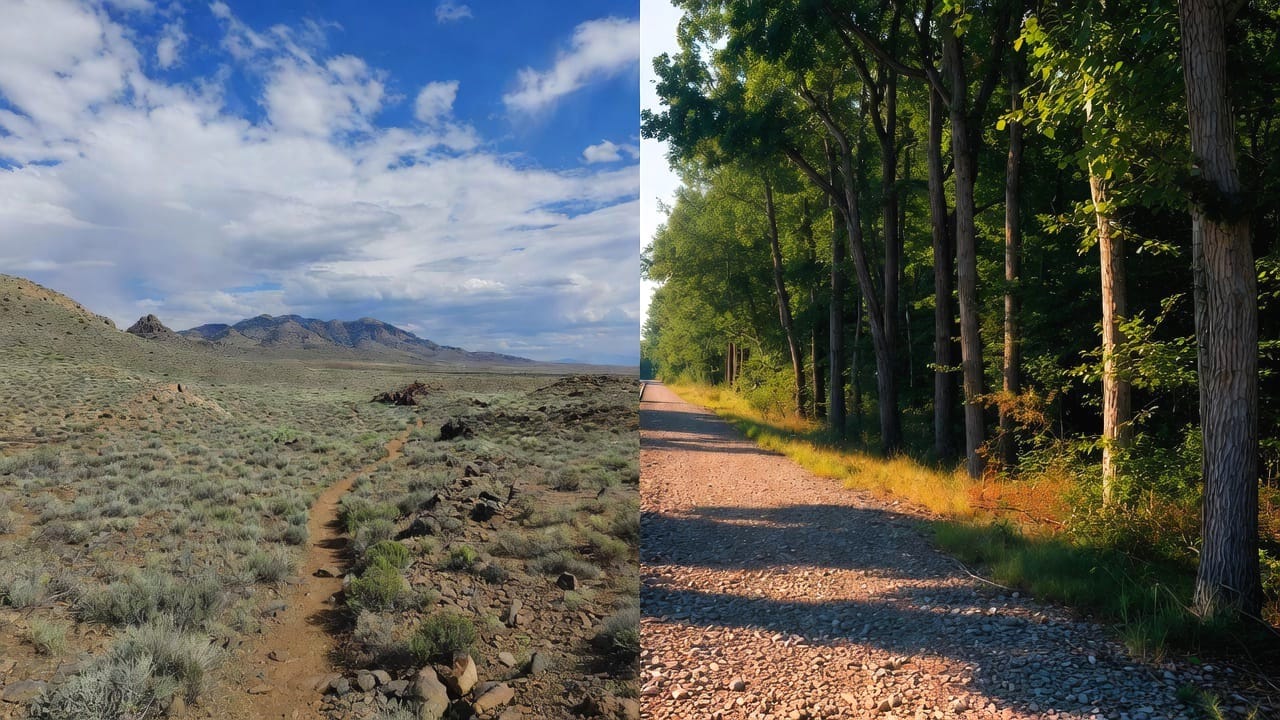
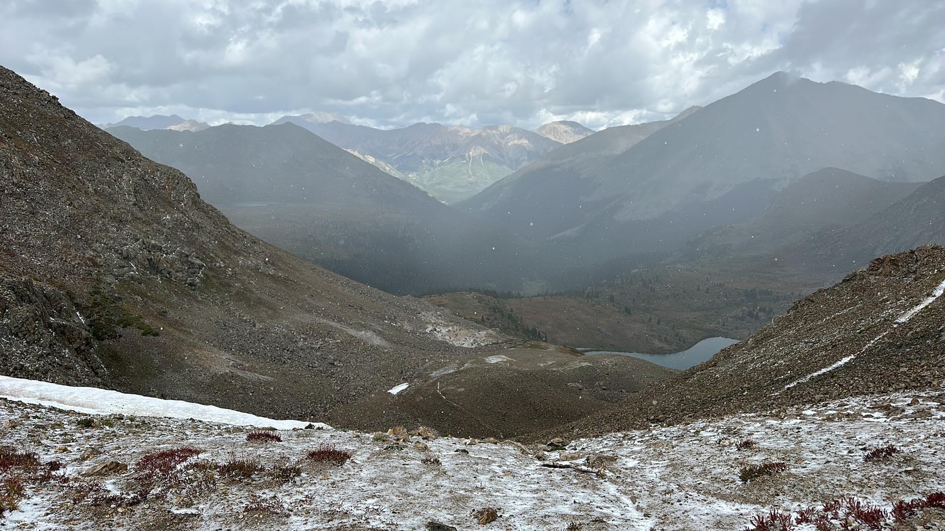
The ADT takes you through genuine backcountry. You'll cross the Sierra Nevada, navigate Colorado's mountain passes (above) above 12,000 feet, hike through the remote deserts of Utah and Nevada, and walk stretches where the nearest town might be 50 miles away. The terrain is wildly varied — urban greenways, rural back roads, singletrack mountain trails, desert crossings, and everything in between. Sections of the ADT are unmarked, and the trail passes through areas where self-sufficiency isn't optional — it's essential.
The Great American is a different kind of journey. The route follows rail-trail corridors — converted railroad beds (below) that tend to be flat, wide, and often paved or surfaced with crushed gravel. The grade is gentler. The terrain is more consistent. Towns are generally more frequent along the route, and the existing trail sections are well-maintained and designed for multiuse recreation.
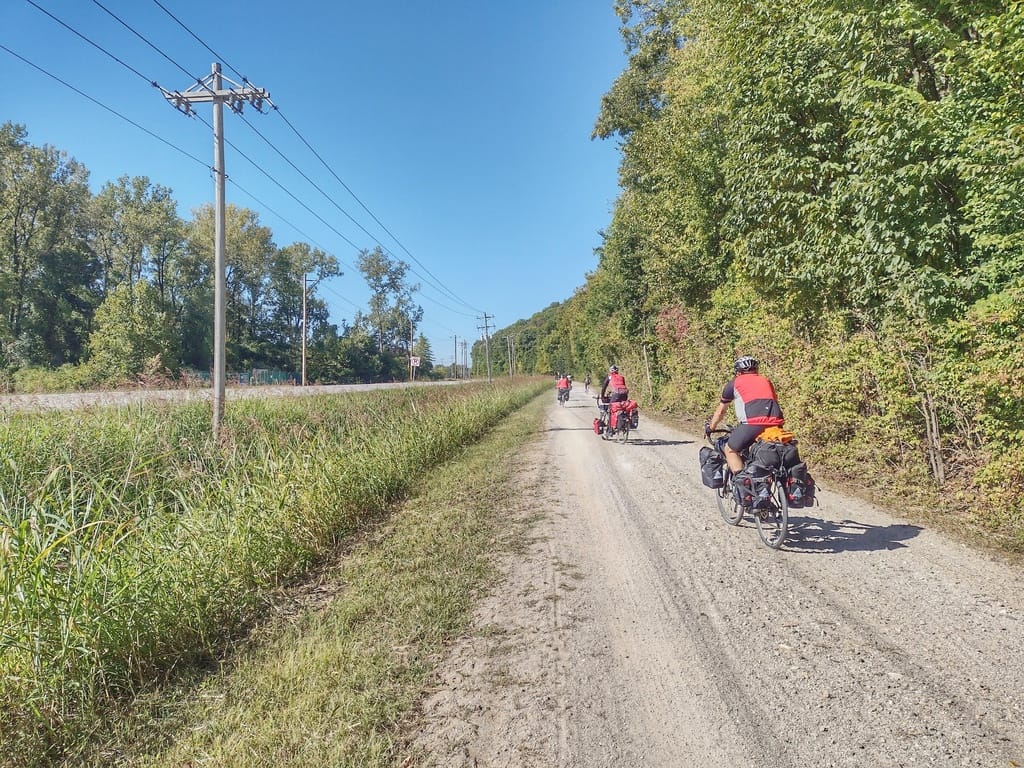
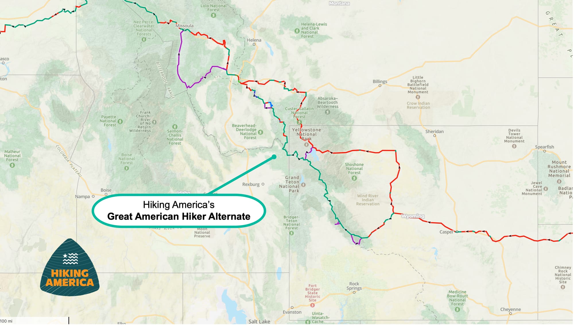
That said, the Great American isn't a sidewalk stroll. The 80+ gap sections between existing trails require routing through areas without trail infrastructure — road walks, forest paths, and in Wyoming and Montana, some genuinely remote terrain. The gap through Wyoming is particularly significant, and Hiking America has created a Hiker Alternate (below) that routes through Yellowstone National Park via the Continental Divide Trail. That section alone is serious backcountry.
Bottom line: The ADT is a wilderness-forward, logistically complex trail that demands backcountry skills. The Great American is more infrastructure-forward with significant exceptions in the gap sections — especially out West.
Navigation and Planning Complexity
The ADT is arguably the most logistically complex long-distance trail in America. It crosses more states than any other trail, traverses more diverse terrain, and requires more detailed planning for water sources, resupply, and route-finding. The trail isn't fully marked end-to-end, and conditions change constantly — detours, seasonal closures, water source fluctuations, and route adjustments are part of the experience.
This is actually the reason Hiking America exists. We built our entire navigation system — dual-directional GPS data, 14,100+ waypoints, turn-by-turn guides — specifically because the ADT's complexity demanded it.
The Great American presents different planning challenges. The existing trail sections are generally well-signed and easy to follow. But navigating the gaps requires careful planning, and because this trail hasn't had thru-hikers walking it before, the on-the-ground intelligence is still being built. Bernie Krausse's 2026 thru-hike is the first known attempt, and Hiking America is documenting every mile of field data as he walks — water sources, camping viability, resupply options, and route adjustments.
Planning a Great American thru-hike right now means working with newer, less-proven data than the ADT. That gap will close quickly as Bernie verifies our routes and we expand our waypoint coverage, but it's worth being honest about where things stand.

Water, Resupply, and Services
On the ADT, water planning is a critical skill. There are sections in Nevada, Utah, and parts of Colorado where you need to carry significant amounts of water, and plan your water sources carefully. Our Gaia GPS waypoints include verified water source data — but "verified" sometimes means "verified as unreliable," which is information you need just as much.
The Great American, with its rail-trail foundation, generally passes through more populated areas more frequently. Resupply options tend to be closer together, and the eastern half of the route especially offers regular access to towns and services. But the western gap sections — particularly across Nebraska, Wyoming, and Montana — present real resupply challenges that are more comparable to what ADT hikers face in remote western sections.


Blackberry Brian, RayRey, California Chrome, Bernie Krausse, Plan Dee
Community and Trail Culture
The ADT has a small, dedicated community. The number of people who've completed or attempted a full thru-hike is remarkably small compared to the Appalachian Trail or Pacific Crest Trail. That means fewer hikers on the trail with you, fewer established trail angel networks, and a quieter, more solitary experience. It also means the community is tight-knit — hikers tend to support each other closely because there are so few of us.
The Great American is just beginning to develop its hiking community. The trail has been promoted primarily as a multi-modal experience — cycling, running, walking — and most of the attention has been on shorter recreational use, not thru-hiking. Bernie's journey is really the first chapter of the Great American's thru-hiking story. If you hike it in 2026 or 2027, you'll be one of the first.
Which Trail Is Right for You?
There's no wrong answer here, but I think it comes down to a few honest questions.
Choose the ADT if you want the full spectrum of American terrain — mountains, deserts, plains, cities, and genuine wilderness. If you want a trail that will test your backcountry skills and self-sufficiency. If you want deep, verified navigation data and a small but tight community of hikers who've walked this path before you.
Choose the Great American if you want a cross-country journey with more consistent terrain and more frequent access to towns and services — while still facing real challenges in the gap sections out West. If the idea of being among the very first thru-hikers on a new trail excites you. If you're drawn to the rail-trail experience and the history of America's railroad corridors.
And if you've already completed the ADT? The Great American is the natural next chapter. Different experience, different challenges, same transformative commitment to crossing a continent on foot. Several ADT completers are already looking at the Great American as their next big walk.
Hiking America Covers Both
Whether you're drawn to the ADT, the Great American, or both — Hiking America provides GPS navigation, trail intelligence, and planning support for the full route of each trail. One subscription gives you access to everything.
The ADT data has been built and refined over years of continuous field verification. The Great American data is complete with GPS tracks and growing daily with service waypoints as Bernie's 2026 thru-hike adds boots-on-the-ground intelligence to every mile.
Get the free Great American GPS tracks
If you want to start exploring, our Great American GPS tracks are available free — no subscription required.
Subscribe to Hiking America
But, for full access to both trails' waypoints, service layers, and turn-by-turn guides, a Hiking America subscription starts at only $7/month.
Cancel anytime.
Whichever trail calls to you, the route is there. 🥾