
How to Hike the Great American Rail-Trail
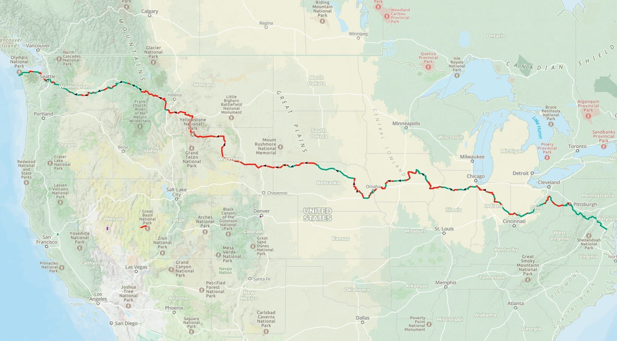
The Great American Rail-Trail is one of the most ambitious trail projects in American history — a coast-to-coast route following converted rail corridors, greenways, and multiuse paths through 13 states. Spearheaded by the Rails to Trails Conservancy, it connects iconic trails like the C&O Canal Towpath, the Great Allegheny Passage, and the Palouse to Cascades State Park Trail into a single transcontinental journey.
The trail is currently about 56% complete, with roughly 2,100 miles of existing trail connected by approximately 1,670 miles of gaps still under development.
Building those final sections will take years — possibly decades.
We decided not to wait.
Can You Hike the Great American Rail-Trail?
Yes — and the first known thru-hike on foot is happening right now.
The Great American Rail-Trail is hikeable today. The trail is approximately 56% complete, with roughly 2,100 miles of existing rail-trail connected by about 1,670 miles of gaps — sections where the future trail corridor exists but the physical trail hasn't been built yet. For cyclists, those gaps are a navigational inconvenience. For hikers, they require verified GPS routing to get through safely.
That's exactly what Hiking America has built. Our complete GPS tracks connect every gap into one continuous, navigable route — so hikers don't have to piece together their own path through uncharted sections.
,
On March 28, 2026, Double-Triple Crown hiker Bernie Krausse stepped away from the Capitol Reflecting Pool in Washington, D.C., and began walking west. His destination: Washington State, roughly 3,800 miles away. Bernie is the first person known to thru-hike the Great American Rail-Trail on foot — and every mile he walks, he's verifying and refining the GPS data that future hikers will depend on.
The trail is here. It's hikeable. And the navigation to do it is available right now.
Wondering what the Great American is actually like on foot? Here's what it looks like for hikers.
What Hiking America Provides
Hiking America has built complete GPS navigation for the entire Great American route — including every gap between existing trail sections. Using existing hiking trails, forest paths, and carefully researched corridors, we've connected the entire route into one continuous, navigable journey.
Here's what's available right now:
Complete GPS Tracks — Full route files covering every mile, including all gap sections. Compatible with Gaia GPS, Google Earth, Garmin, and most major GPS platforms. These are yours free — no subscription required.
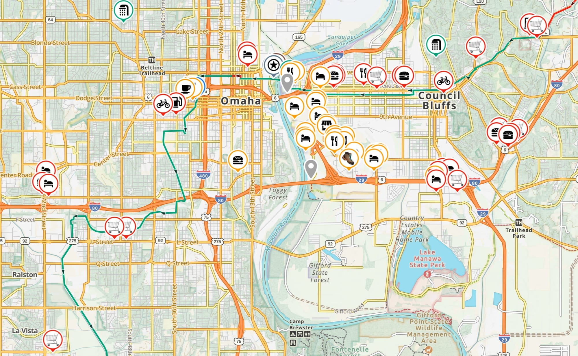
Service Waypoints on Gaia GPS — Resupply points, camping areas, water sources, and hiker notes organized in Gaia GPS. This layer is included in your Hiking America subscription at no additional charge.
Gap Route Navigation — The 80+ sections between existing trails are where hikers need the most support. Our GPS tracks provide verified routing through every gap, so you're never left guessing where the trail picks back up.
What's still in development: Turn-by-turn directions and comprehensive waypoint verification are underway. As Bernie Krausse field-verifies the route during his 2026 thru-hike (more on that below), we're expanding our data with every mile he walks — water sources, camping conditions, trail notes, and route adjustments in real time.
How Long Does It Take to Hike the Great American Rail-Trail?
For most hikers, plan on 5 to 6 months.
Bernie Krausse is averaging roughly 25 to 35 miles per day — a strong, experienced pace that reflects his 57,000 career miles. At that rate, a full thru-hike comes in around 4.5 to 5 months. For hikers who take a more measured pace — 20 to 25 miles per day, with regular zero days — 6 to 7 months is realistic.
For context, that's a longer commitment than the Appalachian Trail (typically 5 to 7 months) but with considerably different terrain. The Great American follows converted rail corridors with low elevation grade, which means less vertical gain than the AT — but longer daily distances are the norm, and the gap sections add navigational complexity that wilderness trails don't have.
A few factors that affect your timeline:
Direction matters. A westbound start in late March or early April — Bernie's timing — puts you through the mid-Atlantic and Midwest before summer heat peaks in the Plains, and gets you into Wyoming and Montana in late summer when conditions are most manageable. Eastbound has its own logic, particularly for hikers who want to start in the Pacific Northwest in early summer.
The Plains deserve honest mention. Nebraska and Iowa are long, exposed stretches with fewer services than the eastern half of the route. Most hikers move faster here out of necessity, but water planning becomes more deliberate.
The gap sections are the biggest variable. The 80+ gaps between existing trail sections vary widely in difficulty — some are short road walks, others are multi-day wilderness routes. Your GPS data determines how efficiently you navigate them.
Whatever your pace, the route is there. The navigation is ready.

Bernie Krausse: Verifying the Route with Boots on the Ground
Bernie Krausse is one of America's most accomplished long-distance hikers — a Double Triple-Crowner and ADT thru-hiker (Class of 2022) with more than 57,000 career miles. In 2026, he's becoming the first known person to thru-hike the entire Great American Rail-Trail.
Hiking America has been working directly with Bernie to map and verify the route. His journey serves as real-time field verification of our GPS data — the same process that made our American Discovery Trail navigation the most trusted resource available.
As Bernie walks, we're updating waypoints, documenting conditions, and building out the comprehensive services layer that serious hikers need to plan their own journey.
Follow Bernie's progress and trail dispatches right here on HikingAmerica.com.
A Hiker's Trail
You've probably seen the Great American marketed as a multi-modal trail, and most of the photos feature cyclists. That's part of the story — but it's not the whole story.
Hiking America is focused on what this trail means for hikers specifically. The planning needs are different. The pace is different. The water carries, the camping considerations, the resupply strategy — all of it changes when you're on foot.
That's what we're building: the hiker's guide to the Great American Rail-Trail.
Already a Hiking America Subscriber?
The Great American services layer is included in your existing subscription — no additional charge. As we build out the data during Bernie's verification hike, it'll automatically appear in your Gaia GPS alongside your American Discovery Trail waypoints.
New to Hiking America?
A Hiking America subscription gives you access to our complete navigation data for both the American Discovery Trail and the Great American Rail-Trail — GPS tracks, service waypoints, turn-by-turn guides, and real-time trail updates. All for one subscription.
$7/month or $70/year — cancel anytime.
Or start with the free Great American GPS tracks and see what Hiking America is all about.
Stay Connected
📧 Subscribe to our newsletter for trail updates and Bernie's dispatches 📱 Follow us on Facebook or join our Facebook Group 📺 Subscribe to the Hiking America YouTube Channel for video updates