
Hiking America's Great American Rail-Trail GPX Files
Hiking America's three GPX files cover the Great American Rail-Trail from Washington, D.C. to Washington State. They are free. You need an email address to get them and nothing else.
What's in the files
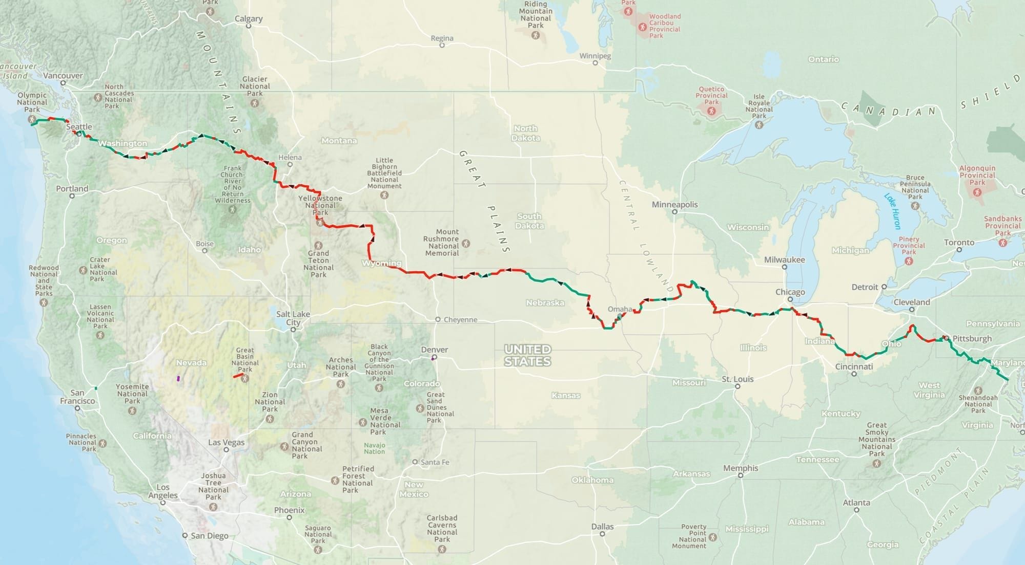
Great American Trails (6.8 MB). The 2,086 miles of built rail-trail: the C&O Canal Towpath, the Great Allegheny Passage, the Cardinal Greenway, the Cowboy Trail, the Palouse to Cascades. Twelve states and the District of Columbia.
Great American Gap Trails (4.7 MB). The 1,674 miles where the corridor exists on paper and the trail does not exist on the ground yet. Rails-to-Trails Conservancy's 2026 Route Assessment puts the route at roughly 56 percent complete, and the missing 44 percent is what stops most people from walking it. These are the routes through, worked out section by section and walked.
Great American Hiker Alternates (4.7 MB). Routes built for people on foot rather than on wheels. Wyoming has the highest percentage of gaps of any state on the route, so the alternate leaves Shoshoni, Wyoming, runs through Yellowstone, and rejoins at Butte, Montana, following the Continental Divide Trail for most of that distance. It trades road shoulder for trail.
Why the gap routing is the part that matters
A cyclist meeting a gap can ride the parallel highway. A hiker on the same shoulder is walking a 15-mile day next to traffic with no water and nowhere to camp.
Every gap on the route has been walked and the line adjusted where the desk research was wrong. The Snoqualmie Tunnel in the Cascades runs 2.3 miles unlit under the crest and closes from November 1 to May 1 most years for falling ice, which sets the outside date on a westbound finish. Details like that are in the files.
Who verified them
Bernie Krausse left the Capitol Reflecting Pool on March 28, 2026 and reached the Pacific at La Push, Washington on August 3, 130 days later. This is believed to be the first known end-to-end foot thru-hike of the Great American Rail-Trail.
He carried these tracks the whole way and logged corrections as he found them. Where the file says a gap route goes through, someone has been through it on foot.
Loading them
The files are standard GPX. They import into Gaia GPS, Garmin Explore and most Garmin handhelds, Google Earth, CalTopo, Ride with GPS, and anything else that reads the format.
In Gaia GPS: Saved, then the import button, then choose the file. Each file lands as its own set of tracks so you can turn the gap routing on and off separately from the built trail.
Reply to any email from us if a file will not load and I will sort it out.
What the files don't include
No water sources, no resupply, no camping, no restrooms, no charging. The tracks tell you where the route goes. They don't tell you where to sleep or fill a bottle.
That layer – roughly 10,000 waypoints – is in Hiking America's Gaia GPS folder, all of it carrying 2026 field verification from Bernie's thru-hike, and it comes with a Hiking America subscription at $15 a month or $89 a year. The same subscription includes the American Discovery Trail data.
Start with the free files. Decide about the rest later.
Questions before you download
Route, surfaces, gaps, water, and how the mountain reroutes work: the Great American Rail-Trail FAQ covers them.
If you're weighing this against a coast-to-coast walk, there's an honest comparison with the American Discovery Trail.