
Three Hikers, One Trail, and a Colorado Running Dry
Three hikers, fifteen hundred miles apart: Tyler 'Iceman' Reiser drops out of the Sierra snow into California, Rhiis and Sara return from a month off near Kansas, and Colorado's snowpack hits a near-record low. Here's where they are — and the water waiting in the high country this summer.

Right now, there are people walking the American Discovery Trail, more than 1,500 miles apart. One is dropping out of the Sierra snow toward Lake Tahoe. Two others are closing out Missouri and about to step into Kansas. Different terrain, different weather. And as they go, each of them is passing notes back up the trail for whoever comes next.
Tyler 'Iceman' Reiser
Westbound - Western Route
Began: April 16, 2026 - Moab, Utah
Support Links: Trail Journals
Tyler 'Iceman' Reiser Crosses Into California
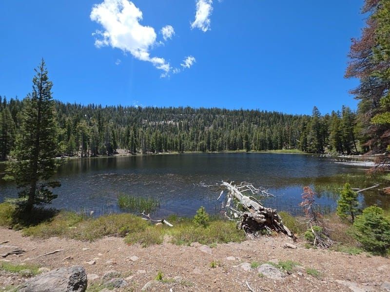
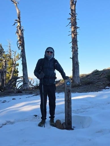
Tyler started westbound from Moab in April. This week he crossed the Nevada–California border, somewhere north of nine thousand feet.
He was up at 5:30 to beat the snow. Cross the ridge early, before the afternoon sun turned what was left to slush — that was the plan. The wind pushed his tent against him as he packed, blowing cold from the south. He crossed into California at 7 a.m. through patches of lingering snow and frost, dropping from over 9,000 feet toward the 8,000-foot line where he figured the snow would quit.
The view, in his words, was "something I will likely remember forever."
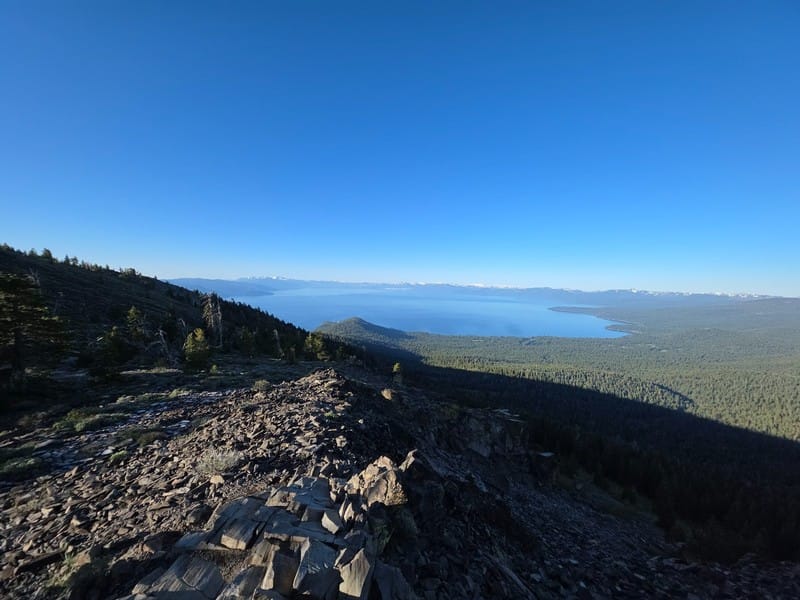
By 8, he'd stopped to make oatmeal in the forest with the sun coming up bright. "I was happy to be walking trail. My mind needed it." The rest of the day ran through meadows and big-tree forest, past Watson Lake, over a vista above the Truckee River, and down to the road into Tahoe City by 6:15 p.m. — a town he'd never seen, regular unleaded at $6.99 a gallon.
He closed the day past a thousand miles since Moab, and signed off the way long-distance hikers do. "I survived another day, again."
Rhiis & Sara
Westbound - Southern Route
Completed: Eastern & Northern Route
Began: February 21, 2025 - Cape Henlopen, DE
Paused: November 5, 2025 - Julesburg, CO
Restarted: March 10, 2026 - Illinois/Indiana Line - Southern Route
Support Links: ImHikingAmerica, TrailJournals, YouTube, Venmo
Rhiis and Sara Are Back
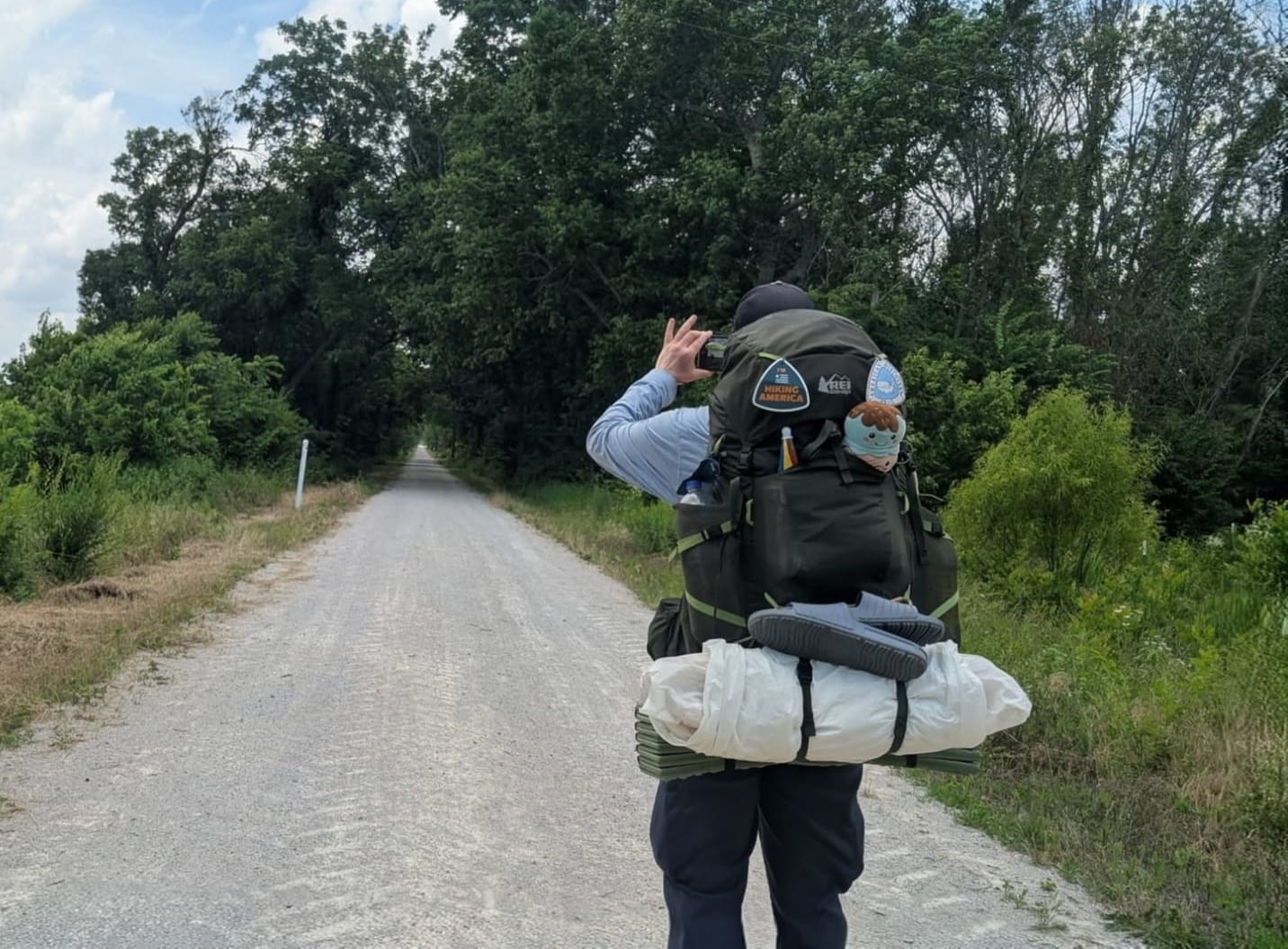
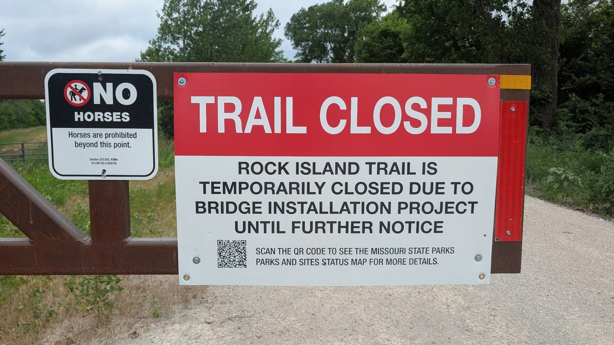
Out in the middle of the country, Rhiis and Sara returned to the trail this week after about a month off while a foot healed. They picked up right where they left off in the spring, on the Rock Island Trail, and they'll finish Missouri and cross into Kansas this week.
Coming back after time off is its own kind of hard. The body has to remember the work, and the trail doesn't slow down to welcome you. They've done it quietly.
And they've come back generous. Since returning, they've already added more than a dozen waypoints for services and camping along their stretch as well as reconfirming a trail closure expected to last through the end of the year — small contributions that smooth the path for everyone behind them.
What's Waiting in Colorado
Once Rhiis and Sara clear Kansas, Colorado is next. And if you're heading into the high country this summer, the water needs a hard look this year.
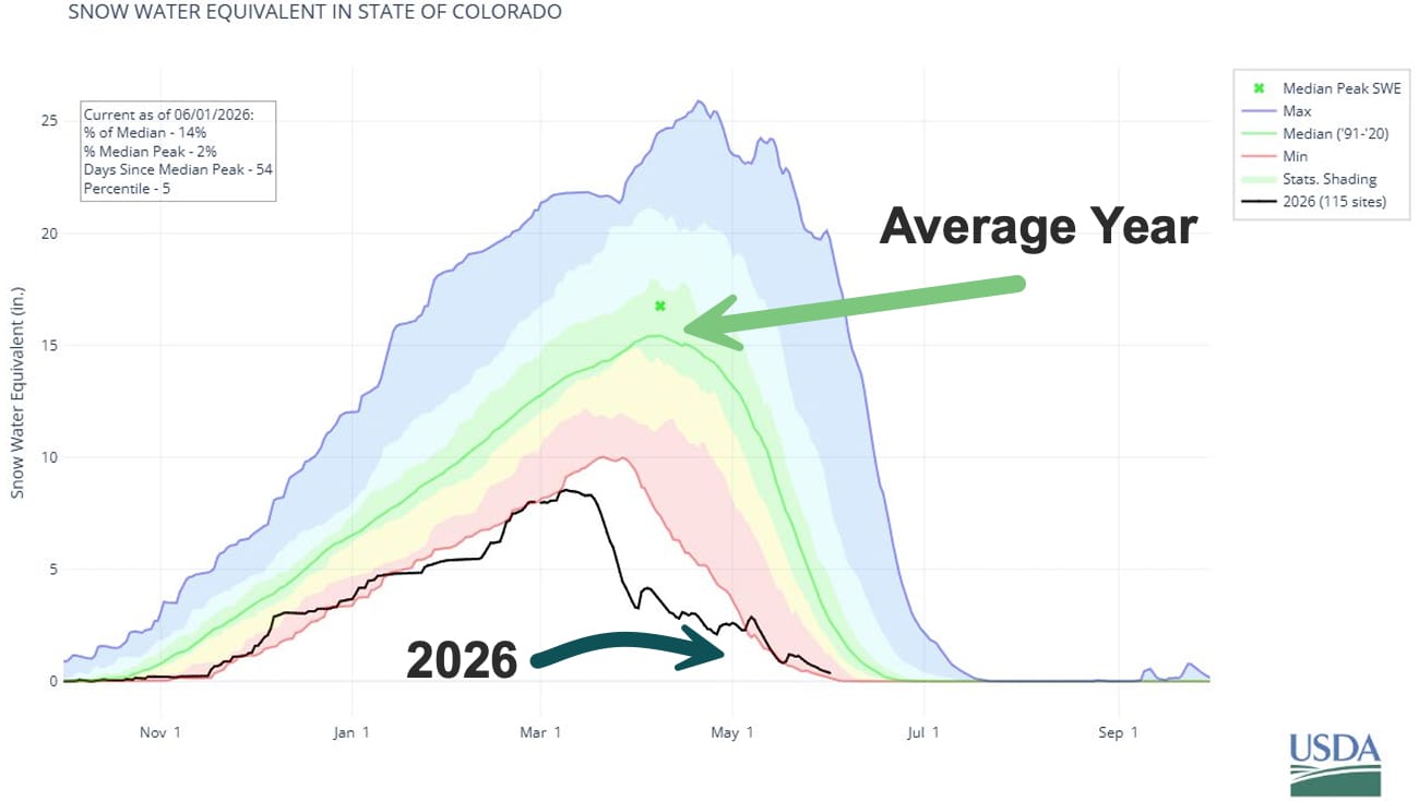
Back in the spring, we flagged Colorado's low snowpack and warned the melt would come early and light. It did, and then some. The June 1 USDA Natural Resources Conservation Service report is in, and the snow that usually feeds Colorado's creeks deep into summer is mostly gone. Statewide snowpack sat at 14% of the median on June 1, the third-lowest June on record. By that date, 91% of the state's snow stations had melted out — in a normal year it's 56%. Summer streamflow is running near a quarter of median.
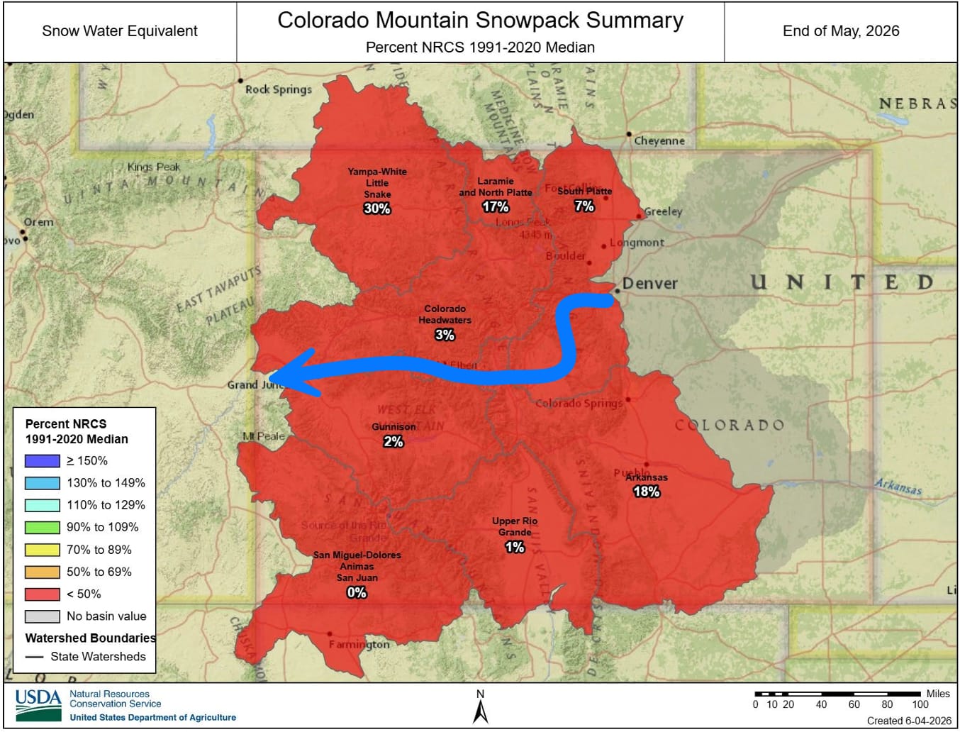
The ADT crosses three Colorado River basins, and briefly a fourth, and they're not in equal shape.
The South Platte, along the Front Range, came through best. Snowpack hit just 7% of median, but May was wet here at 140%, and reservoirs sit at 90% — better than this time last year. Summer flows forecast out between 33% and 64%, the high end at St. Vrain Creek near Lyons north of the ADT track.
The Colorado Headwaters runs tighter. Snowpack landed at 3%, reservoirs at 80% (down from 101% a year ago), summer flows between 16% and 36%.
The Gunnison is the one to plan around. Snowpack finished at 2% of median, May was the driest of the three, reservoirs sit at 70%, and a few streamflow forecasts start as low as 7%. Through the Gunnison corridor, en route to Grand Junction, carry more water than you think you need.
The small creeks, springs, and seasonal drainages hikers lean on will run low or dry weeks earlier. A creek that ran clear in late June of a normal year may be a dry bed right now.
It's not all caution. Reservoirs across all three basins are holding between 70% and 90% of median, so town water is fine — fill up in resupply with confidence. Low flows also make any stream crossings on your route easier. NOAA is calling for near-normal to slightly wet conditions in June, so you may catch some afternoon relief. Watch the flip side, though: a dry year pushes up wildfire risk, and seasonal fire restrictions or closures are likely.
We fold all of this into our Gaia GPS waypoints as it comes in — water, services, camping, the small fixes like a grocery store that relocated this year (thanks, Tyler). If you're out there, your notes help the people behind you.
Tyler, Rhiis, Sara — keep going. And thanks for sending word from the field. 🥾⛰️
Hike Your Hike - John.
Ready to Start Planning Your Route?
A Hiking America subscription gives you access to the complete ADT waypoint library, dual-directional GPS data, and turn-by-turn guides for the full trail — organized so you can plan section by section, in whichever direction works for you.
Subscriptions start at $7/month. Get your navigation sorted and take that first step with confidence.

Water conditions here come from the USDA NRCS Colorado Water Supply Outlook Report, June 1, 2026. In a dry year, things change fast — confirm water sources and local rules before you count on them. If you want to talk through a specific section, reach out. That's what the concierge is for.